|
Harvey’s Wobbles
The Earth wobble has gotten worse, and Hurricane Harvey proved
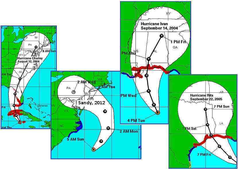
that. Hurricanes historically move in a slow curve, known as the
Cone of Uncertainty. Even where a hurricane makes a 90 deg turn,
as Sandy did in 2012, they do so in an even curve, moving
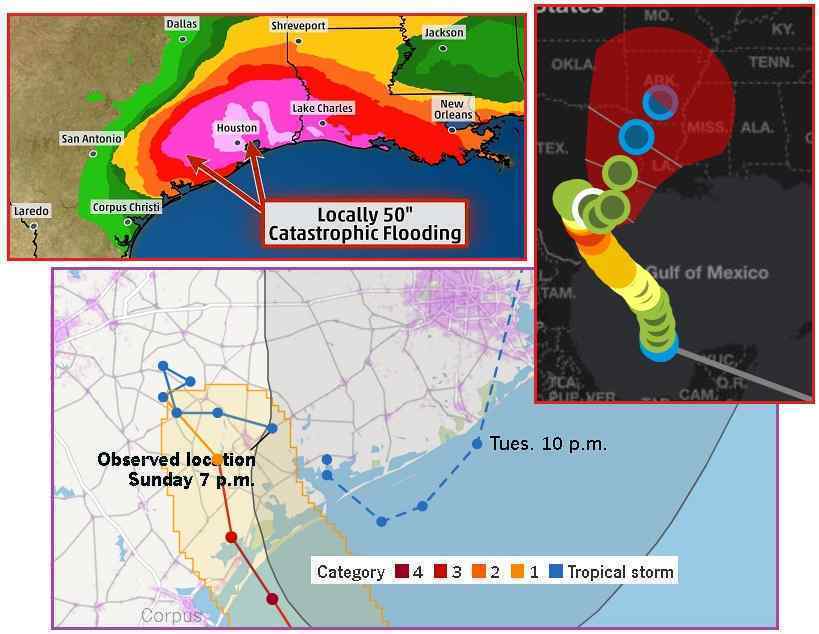
forward at all times. But not Harvey. Harvey made landfall at
Corpus Christi, moved inland into central Texas, and then backed up! Per the Zetas,
this accounts for the failure of Houston’s Mayor to evacuate the
city. Houston was not in the original path!
- Rescuers Pluck Hundreds from Rising
Floodwaters in Houston
August 28, 2017
https://apnews.com/1be70a05bd0848c9aba361ab509d0fce/Rescuers-pluck-hundreds
- Before the storm that arrived
Friday as a Category 4 hurricane is gone, some parts of
Houston and its suburbs could get as much as 50 inches
(1.3 meters) of rain. That would be the highest amount
ever recorded in Texas. Conflicting advice given by the
governor and Houston leaders before the hurricane -
Governor Greg Abbott urged people to flee from Harvey’s
path, but the Houston mayor issued no evacuation orders
and told everyone to stay home citing the risks of sending
the city’s 2.3 million inhabitants onto the highways at
the same time.
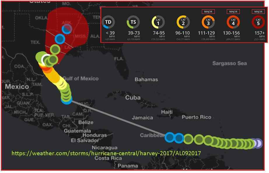
Harvey’s path was not
a smooth curve but looked more like a snake as it
meandered through the Caribbean. It was first at Tropical Storm
strength, then dropped to Tropical Depression strength, then as
it took aim at Corpus Christi became a Category 4 hurricane.
Notably, it was also moving faster
than expected, which is a push the wobble and only the wobble
could accomplish.
- Harvey, Now a Tropical Storm, Carves
a Path of Destruction through Texas
August 26, 2017
https://www.nytimes.com/2017/08/26/us/hurricane-harvey-texas.html
- Hurricane Harvey, powered by the
Gulf of Mexico’s warm waters, made landfall as a Category
4 hurricane at about 9:45 p.m. Friday, earlier than
expected.
But what was most dramatic was that it stopped in central
Texas and reversed.
An unprecedented move. This reversal cannot be denied. This did
not happen for Hurricane Ivan in 2004 or Hurricane Rita in 2005.
When Hurricanes hit land they diminish to a Tropical Storm and
proceed along their path. They do not reverse.
The Zetas explain.
ZetaTalk Insight
8/31/2017: Harvey
enters the Caribbean as a Tropical Storm, drops to a Tropical
Depression, then returns to build wind speed into a Category 4
hurricane prior to landfall. Why did it weaken and then return
to be a Category 4 hurricane? The cone of a hurricane is
normally an even curve. But Harvey weaves back and forth like
a snake, then reverses direction, pulling away from the
coastline before returning to slam Houston. Houston was not
originally in its path, thus the Mayor’s wrong call on
evacuations.
The factors that affect the force of a hurricane are usually
consistent, not wavering, which shows the effect of the Earth
wobble on both water and air masses. The Gulf deals with both
the Polar Push forcing water and air away from Texas, and then
the bounce back or the swing to the right and left relieving
or increasing pressure. We warned in 2006 that there would be
coastlines that would become virtually uninhabitable, due to
the Earth wobble induced assaults. After hurricane Katrina and
now Harvey, it is becoming obvious that the Gulf states are
among those locations.
But Harvey was not done showing the world that Nibiru was
nearby. Texas was breaking records, the highest rainfall ever.
Overtopping the levees and threatening to break the reservoir
dams upstream from Houston, the 4th largest city in the US was
braced for even more flooding.
- Tropical Storm Harvey Rainfall Still
Soaking Flood-Ravaged, Texas, Louisiana
August 29, 2017
https://weather.com/storms/hurricane/news/tropical-storm-hurricane-harvey-rain
- Periods of torrential rain will
continue over parts of Texas the next several days with
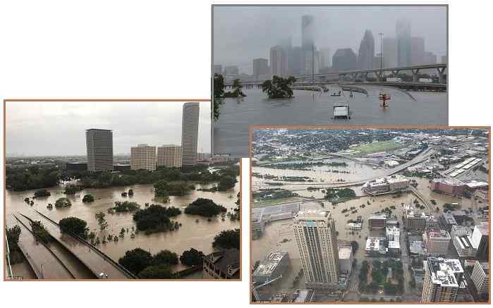
more flooding likely. Tropical Storm Harvey has stalled
over southeast Texas where extreme rainfall has occurred
in the Houston metro area, leading to record-breaking,
catastrophic flooding.
- 'Please Send Help!'
August 28, 2017
http://www.dailymail.co.uk/news/article-4828968/Thousands-trapped-rooftops
- FEMA, the Federal Emergency
Management Agency, revealed it would take the area years
to recover from the storm which is the worst this decade.
Houston, the nation's fourth largest city, was told by its
mayor not to evacuate and thousands were forced to seek
higher ground due to the rising waters. Several hospitals
in the Houston area were evacuated due to the rising
waters.
There were warnings in the press that the region might be
“uninhabitable” in the future. Humm, where have we heard this
before? Ah, from ZetaTalk, in 2006. A prescient prediction as
Hurricane Harvey was not about to let the Gulf coast alone. Even
after becoming a Tropical Storm, it kept backing up and returning
to the Gulf to slam the coastline once again.
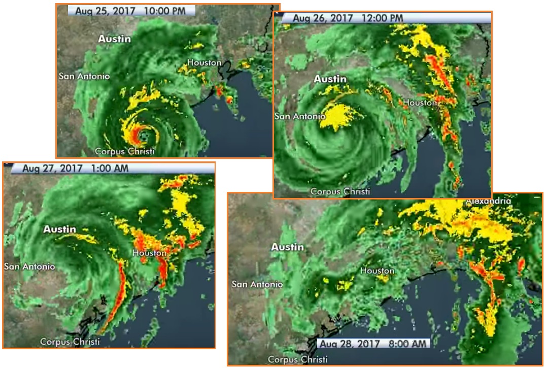
- Powerful Hurricane Harvey Makes
Landfall in Texas
August 25, 2017
http://www.cnn.com/2017/08/25/us/hurricane-harvey/
- The combination of wind and water
could leave wide swaths of South Texas "uninhabitable for
weeks or months.
- Harvey Returns to Gulf
August 29, 2017
http://halturnerradioshow.com/index.php/news/u-s-national-news/1130-harvey-returns
- The "eye" of former Hurricane
"Harvey" has returned to the warm waters of the Gulf of
Mexico and the storm is once again strengthening.
Sustained winds have now increased to 45 MPH with stronger
gusts. Lake Charles Louisiana is already flooding. Baton
Rouge is under flash flood warning and New Orleans is in
grave danger from "catastrophic" flooding as nine inches
of rain are projected to fall. Harvey is expected to move
into the Gulf of Mexico before moving up the coast through
Louisiana.
ZetaTalk Prediction
8/26/2006: We
have predicted that coastlines will become uninhabitable, in
many places, so that crops are grown but man sleeps restless
there. The degree of assault on coastlines that will occur as
the Earth wobble increases is hardly imagined.
Meanwhile, the oil and gas center of the US and the 4th largest
city, Houston shows poor planning. The reservoir system was not
designed for a city this size. Nor did anyone contemplate
rainfall of this scale. Both have combined to create a
catastrophe that was, to use the words of the Zetas, “hardly
imagined”. But Houston, and the US, is not alone. All cities, in
all countries worldwide, are not prepared for what Nibiru will
bring. It has only started. And no one is prepared.
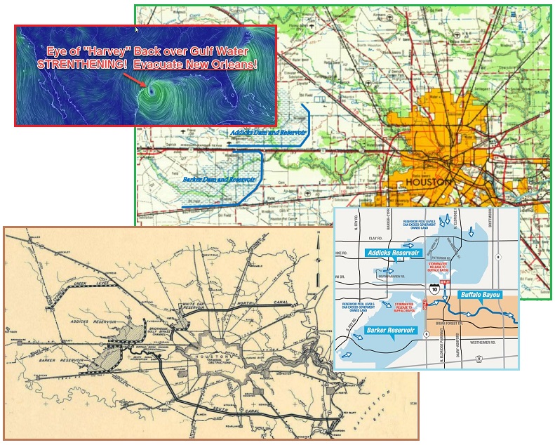
- What Happened to the Two Reservoirs
that were Supposed to Protect Downtown Houston?
August 28, 2017
http://www.slate.com/blogs/moneybox/2017/08/28/what_happened_to_the_reservoirs
- Houston’s planning has been
overwhelmed by unregulated urban growth and a storm no one
thought possible. There are three places for the water to
go: through the dam gates, down the emergency spillways
along the sides of the dams, and upstream into the
neighborhoods. Officials think the water will likely go in
all three directions.
- Three Dams begin to Release Water due
to Hurricane Harvey in Houston
August 29, 2017
http://news.xinhuanet.com/english/2017-08/29/
- Three dams in Houston area began
to release water due to a dramatic rise in the water level
brought by Tropical Storm Harvey. The decision to release
water from overfilled reservoirs is to avoid a collapse of
the reservoirs' dam.
Early in the ZetaTalk saga the Zetas warned against what they
called melting soil under the influence of flooding. Stagnant
water, lingering longer than usual, can melt soil. If the water
is on the move, draining, it can scour the soil. Buildings and
bridges and roadways are undermined, destabilized. This is now
being reported for the Houston area. The Zetas warned of this
type of unexpected destabilization in particular for Paris,
Berlin, and Dallas.
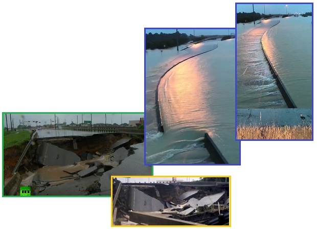
- Houston says Bridges, Roads starting
to Fail under Stress of Flooding
August 29, 2017
http://af.reuters.com/article/commoditiesNews/
- Some roads and bridges in Houston
are starting to buckle under the impact of catastrophic
flooding in parts of the city from Tropical Storm Harvey.
One bridge had collapsed and that some roads had been
damaged by the torrential rains.
- Harvey Floodwaters Overflow Houston
Reservoir, separate Levee Breach Reported
August 29, 2017
http://www.foxnews.com/us/2017/08/29/harvey-floodwaters-put-houston-reservoirs
- Bridges, roadways and other
structures are beginning to fail in some parts of Houston
due to excess water.
ZetaTalk Dallas
2001: Water
does damage that those viewing film of floods cannot imagine,
unless one were viewing the effects of the flood waters as
they encroach. Water melts the substrata, as well as presses
against foundations not built to resist such pressures. Thus,
unless constructed on solid rock and with thick walls, most
structures will lean in the winds and be pushed over by the
rising water.
ZetaTalk Paris
2001: The
flood tide during the shift will curl quietly around buildings
and along roads and streets, flooding basements and
foundations until the ground under them becomes soft so that
tipping sideways or sinking can occur, breaking windows as it
rises to flood lower levels and prevent escape in any
direction except by boat, and ultimately rising over rooftops
so that frantic residents are padding for their lives.
ZetaTalk Berlin
2001: During
the shift itself, water rushing into the Baltic Sea during the
sloshing of the Atlantic, and slow to drain back out due to
the relatively narrow straits, will cause flooding of any
lowlands along the Baltic Sea. Berlin will find a flood tide
rolling in, and stagnant for days. The effect of putting
cities not used to flooding nor designed for this under water
for long periods is that soil melts under foundations and
building otherwise sound suddenly slide when underwater
mudslides take place. No roof can thus be considered safe or
secure, and boats and rescue should be part of the plan for
those resigned to ride out the shift in Berlin.
ZetaTalk Prediction
2010: Our
advice to be 100 miles from a coastline and 200 feet above sea
level to avoid the coastal tidal waves during the pole shift.
Research the effect of swollen rivers which will likely be in
a backwash during the pole shift. We have stated that all
rivers will be over their banks, so the worst possible
scenario should be assumed. What will happen if the river
cannot drain? Despite having a good sea level elevation, any
land that does not have an advantage of being at least 200
feet in elevation over a major river bottom in the vicinity is
likely to be flooded. A backwash from the main river in your
vicinity should be assumed, so that creeks will not drain, for
instance. Water on the move tears and bites and scours, and
will undercut the soil under buildings so they will tilt and
tumble. Being on solid rock that will not melt in this
scenario is advised.
Flat Earth
Confusion
Surprisingly, the Flat Earth society claimed the Eclipse
delivered proof of their assumptions. The Eclipse took 2-3
minutes to zip across the American Continent, moving faster than
the rotation of the Earth (which takes 4 time-zone hours to pass
under the Sun), faster than the orbit of the Moon (which takes
28 days to orbit the Earth). The Eclipse was visible from the
West Coast to the East Coast, moving in a West to East
direction. Yet the East Coast should be the first to encounter
the Moon! What’s up with that?

- Flat Earth Believers say Solar
Eclipse Proved Earth is Flat
August 25, 2017
http://anonymous-news.com/flat-earth-believers-say-solar-eclipse-proved-earth-flat
- Flat Earthers question that if
the Earth is rotating from west to east, the shadow cast
by the Moon should pass across Earth’s surface from east
to west, just as the Sun moves across the sky.
- Orbit of the Moon
https://en.wikipedia.org/wiki/Orbit_of_the_Moon
- When viewed from the north
celestial pole, i.e. from the approximate direction of the
star Polaris, the Moon orbits Earth anticlockwise and
Earth orbits the Sun anticlockwise, and the Moon and Earth
rotate on their own axes anticlockwise.
The Zetas explain that though this might seem that the Moon itself is moving
rapidly during those 2-3 minutes, the Moon in fact is close to
the Sun that day in views from all over the world. It was a
small change in position that allowed the Moon to align,
exactly, with the Sun, producing the Total Eclipse. This small
change in position is explained, below, by the Zetas as due to
the tilt of the Equator as the Earth rotates during the day, and
the normal tilt of the Moon’s orbit. Sorry Flat Earthers, the
Earth is still round.
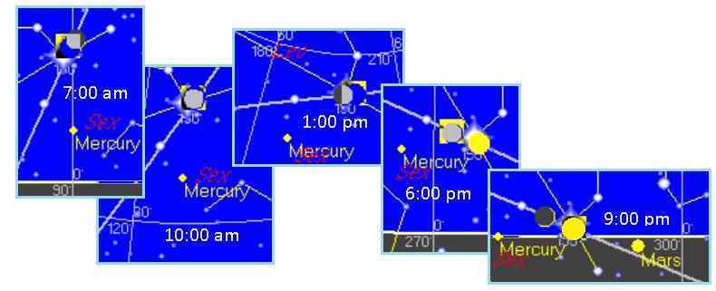
ZetaTalk Explanation
8/31/2017: It
would seem to be illogical that the Eclipse was first viewed
on the West Coast and then moved to the East Coast, when the
East Coast would be the first to encounter the Moon on that
day. The Eclipse took place in just over 2 minutes, when it
takes 24 hours for the Earth to rotate and 28 days for the
Moon to orbit the Earth. Both are moving from West to east. So
what happened that the Eclipse did a flash dance in just over
2 minutes? The answer lies in the tilt of the Moon’s orbit vs
a vs the tilt of the Earth.
Any given point on the
Northern Hemisphere is not parallel to the Ecliptic, the Sun’s
middle where her planets slings out in a ring. At dawn, the
Ecliptic slants lower left to upper right, and at dusk, from
upper left to lower right. The tilt during the day is not
insignificant. Though the Moon orbits the Earth at a tilt,
during the New Moon, which was present on August 21, it is
positioned on the Ecliptic. This can be seen by Skymap images,
wherein the Moon is directly on the Ecliptic and virtually on
top of the Sun the entire day, though only when the Moon is in
line with the Sun is the Eclipse apparent.
The Sun is static but setting
ever so slowly in the West. The Moon is static but moving ever
so slowly to the East, its direction of orbit. What can be
seen on the Skymap images in the view from Portland, Oregon is
that the Moon is on the right of the Sun at 7:00 am but on the
left of the Sun by 6:00 pm. But what is moving during those 2
minutes is the view from Earth where the overlay by the Moon
is complete? The tilt of the Earth, which is not
insignificant, has placed the view where the overlay is
complete in different locations.
LA Urban Gardener
Urban gardening is more than flowers in window boxes. It can be
self-sufficiency, where neighbors join in and share produce,
save seed, and create soil from earthworms busy in the compost
pile. Free ranging chickens and fish tanks can add to the
protein in the shared meals.

We have featured these ventures in this newsletter in Issue
341 for Growing Power in Milwaukee, Issue
508 for suburban gardens in Orlando, Issue
363 for utilizing vacant lots in cities, and Issue
109 for free ranging chickens in urban areas.

Now yet another example of urban gardening has emerged in the
heart of the Bloods and Crips area of LA. This goes beyond
gardening and its benefits, it reaches to the spirit and soul of
those who live there. Plaudits to Ron Finley for his efforts.

- The real OG (that's Organic Gardener)
of South Central L
August 22, 2017
http://www.dailymail.co.uk/news/article-4812742/Ron-Finley-wants-end-food-slavery
- Ron Finley grew up in South
Central Los Angeles during an era that glorified gang
life. He was raised by a ‘hustler’ father and factory
worker mother at a time when Bloods and Crips were
beginning to establish a reputation of violence in his
neighborhood – the area where he still lives today. His
mission now is to create an outlet for kids in South
Central in an area that is devoid of many of the things
they need – healthy food, outdoor activity, and
opportunities for advancement. He then founded a group
that set about establishing community gardens across the
city – in homeless shelters, empty lots, and other
parkways. He began to build in the abandoned pool behind
his home - planting trees, fruits and vegetables that
would later become the thriving urban jungle for which he
is best known. Before long he had fresh pomegranates,
lemons, peppers, squash and carrots: a menagerie of
practical organic foods the neighborhood desperately
needed, and were open for the taking.
|

